Back to the BIM & IFC blog
Digital twins · 2026-08-27 · 10 min
How to View an IFC on a 3D Map: Georeferenced BIM in the Browser
Open a real IFC4 pavilion in its Barcelona map context, inspect the live 3D demo, and learn how IfcProjectedCRS and IfcMapConversion place BIM correctly.
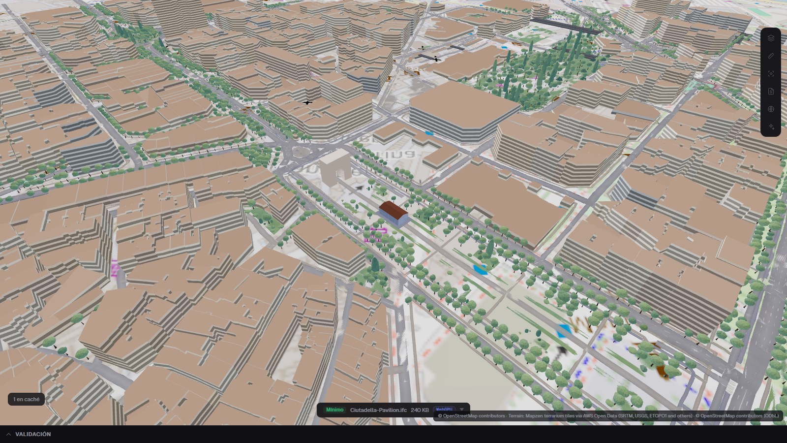 Actual IFC Viewer Online capture showing the georeferenced Ciutadella Pavilion inside a detailed 3D map of Barcelona
Yes: you can view an IFC on a 3D map directly in the browser. The useful version of that sentence is not “put a building near a pin”; it is “read the model coordinate reference system, preserve the engineering geometry, and align terrain plus GIS context around it”. The live example below does exactly that with a small IFC4 pavilion in Barcelona.
- 4 — IFC schema
- 240 KB — example file
- 137 — model elements
- EPSG:25831 — projected CRS
Actual product capture from the reproducible deep link. The pavilion is the authored IFC; the city, terrain and trees are surrounding map context.
Try the IFC + 3D Map Demo
Start the example to load the bundled IFC locally and then request its 3D site context. Orbit, zoom and open the full viewer if you want the complete map controls. External map services can take a few seconds to stream terrain and surrounding features.
Ciutadella Pavilion — georeferenced IFC on a 3D map
A bundled 240 KB IFC4 model aligned automatically in Barcelona through EPSG:25831 and IfcMapConversion, with optional terrain and OpenStreetMap surroundings.
IFC and map are ready — drag to orbit
What Makes a Map Placement Trustworthy?
The official buildingSMART definition says IfcMapConversion transforms a local engineering coordinate system into the coordinate reference system of the map using scale, rotation and translation. IfcProjectedCRS identifies that map coordinate system. Those two pieces answer different questions and are both useful.
| IFC information | Question it answers | Confidence in this workflow |
|---|
| IfcProjectedCRS | Which projected map grid and datum? | High when the EPSG definition is resolvable |
| IfcMapConversion | Where is the local origin, at what rotation, height and scale? | High for automatic placement |
| IfcSite RefLatitude / RefLongitude | Where is the site approximately? | Approximate fallback |
| Manual map pin | Where should an ungeoreferenced model be shown? | User-provided, not surveyed |
Opening successfully is not evidence that an IFC is located correctly. The placement source must remain visible. The map aligns around the local model. Keeping geometry near the project origin avoids sacrificing rendering precision to very large global coordinates.
The Ciutadella File Is a Reproducible Test, Not a Mock-up
The example is intentionally small enough to inspect. It is a 24 × 12 m exhibition pavilion on a 4 × 6 m grid, with a foyer, mezzanine gallery, double-height hall, glazed façades and pitched standing-seam roof. Its role is to make placement errors obvious against a recognizable street axis.
- IFC4 file: BCN-IVO-ZZ-XX-M3-Z-0003.ifc, 240 KB and 137 model elements.
- Target CRS: EPSG:25831 — ETRS89 / UTM zone 31N.
- Map origin: E 431543.18, N 4582439.59, orthogonal height 18.5 m.
- Project X axis: (0.700909, −0.713250), which places the pavilion at roughly −45.5° to grid east.
- Site: Passeig de Lluís Companys, about 80 m from the Arc de Triomf and oriented with the promenade rather than square to north.
#63=IFCPROJECTEDCRS('EPSG:25831', ...);
#64=IFCMAPCONVERSION(#10,#63,
  431543.18,4582439.59,18.5,
  0.7009092643,-0.7132504492,1.0);
The model and its Blender/Bonsai generation script are public, so the screenshot and live scene can be rebuilt instead of taken on trust.
What the 3D Map Adds to an IFC Viewer
Orientation you can verify
Street axes and neighbouring geometry reveal a wrong north angle immediately.
Terrain context
Relief gives the model a ground reference while a height offset handles datum differences explicitly.
Surrounding massing
OpenStreetMap buildings, water, parks, trees and bridges provide site context without becoming IFC elements.
Engineering coordinates preserved
The model remains in its local metre-based frame; the basemap moves into the scene rather than rewriting the IFC geometry.
Local IFC Privacy and Online Map Requests Are Separate
IFC processing
- File bytes parsed in the browser
- Geometry stays on the device
- Local project coordinates preserved
- Works without creating an account
Map context
- Downloads tiles or terrain from the selected provider
- Requests OpenStreetMap surroundings when enabled
- Requires provider attribution
- Needs network access and provider availability
OpenStreetMap requires visible credit and notice of its ODbL terms. The viewer keeps that attribution inside map captures; the official OpenStreetMap copyright page explains the requirement. Hiding the attribution to make a cleaner marketing image would make the image less trustworthy and non-compliant.
How to Put Your Own IFC on a 3D Map
- Open the IFC in the browser and inspect its site and coordinate metadata before enabling map layers.
- Open Map mode. If the file contains a resolvable projected CRS and map conversion, review the detected location, rotation and confidence.
- If the file only contains site latitude/longitude, treat the result as approximate and compare it with known site control.
- If no usable georeference exists, place the model manually and label that placement as user-provided rather than surveyed.
- Enable terrain and surroundings one layer at a time, then verify the street axis, footprint, height and nearby landmarks.
- Keep the attribution visible in screenshots, reports and client presentations.
The Visual Promise — and Its Limit
 Conceptual editorial illustration generated for this article. It communicates the IFC + GIS idea; it is not a product screenshot, survey or representation of the Ciutadella Pavilion.
A convincing 3D map is useful. A visible coordinate source, confidence level and reproducible model are what make it authoritative.
IFC Viewer Online
For measured reality beside the model, continue with IFC + point-cloud Scan-to-BIM alignment. For time-based site evidence, see IFC + video on 3D terrain.
How to View an IFC on a 3D Map: Georeferenced BIM in the Browser