Back to the BIM & IFC blog
Digital twins · 2026-10-10 · 9 min
The River That Is Not There: Buried Watercourses and Flood Risk Around a Building
Cities were built over streams. The streams were piped, filled in or diverted; the valleys they cut were not. When a storm overwhelms the drains, water goes back to where the stream ran. OpenStreetMap often still records those courses. How to find them, and see what the rain does over them.
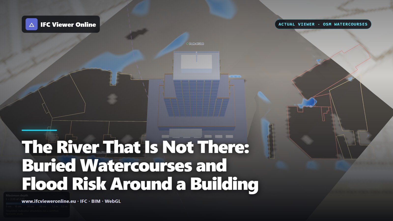 Flood simulation over Poblenou, Barcelona, seen from above: the Torre Poblenou IFC, neighbouring buildings from OpenStreetMap outlined in amber and red where the water reached them, and a dashed violet line along a buried watercourse
La Rambla, Barcelona's best-known street, runs along the bed of a seasonal stream that once followed the medieval walls. In Catalan and Spanish a riera or a rambla is exactly that, a stream that is dry most of the year, and the city grew over dozens of them. Streets like Riera de Sant Miquel and Riera Blanca still carry the word in their names. Most were piped under the streets, or filled in, as the city spread over the plain.
Barcelona is not unusual. London built over the Fleet and the Tyburn; Seoul covered the Cheonggyecheon with a road and uncovered it again in 2005. What these cities share is that the ground still has the shape the streams gave it. When a storm overwhelms the drains, surface water goes back to where the stream ran.
Key takeaways
- A buried river leaves the lowest line through a neighbourhood. In a storm that overwhelms the drains, water follows it.
- OpenStreetMap often keeps those courses, under lifecycle prefixes (disused:, abandoned:, was:…) or as long culverts.
- IFC Viewer Online's flood simulation marks them with a dashed violet line, does not carve them into the ground, and measures the water over them.
- Where OpenStreetMap says nothing, a bare-earth terrain model still shows the valley, and the simulation finds it on its own.
 Torre Poblenou, Barcelona: the extreme storm (120 mm in 2 hours) on the ICGC relief, 2 m cells. The dashed violet line is a watercourse OpenStreetMap records as gone or piped; amber and red outlines are the neighbouring buildings the water reached.
Why a river that is gone still matters
A bare-earth elevation model[icgc-met] strips away the buildings and keeps the shape of the ground. Over a city built on streams, it still draws their beds.
- The valley stays. The old beds are the lowest lines across the neighbourhood, and surface water finds them first.
- Culverts have a capacity. A stream piped under the streets carries what its pipe can. In a cloudburst the excess comes up, and it comes up along the old course.
- Fill settles, and it is often less permeable than the gravel it replaced.
- Buildings stand in the old beds: basements, car parks and ground floors at the lowest point of the street.
How OpenStreetMap records a watercourse that is gone
OpenStreetMap maps what exists, but it has a convention for what used to: a lifecycle prefix on the key[osm-lifecycle]. A river that was filled in can stay as a line tagged disused:waterway=river, abandoned:, historic:, was:, razed:, removed: or demolished:waterway. Older edits do the same with waterway=* and disused=yes. A stream carried under a road or a building is mapped as the waterway with tunnel=culvert[osm-culvert], and in a city that culvert can run for hundreds of metres.
 The tags the flood simulation reads, and what it does with each.
Culvert or vanished: why the simulation treats them differently
An open stream is carved into the simulation's ground by its depth (tagged, or 0.6 m for a stream, 2 m for a river), so the water runs in its channel. A short culvert under a road is carved too: without it, every road crossing would dam the stream.
A long culvert is different. Barcelona maps some of its old watercourses as streams in culverts for hundreds of metres under the city. Carving those into the ground drew canals through city blocks, which was the first thing we measured when we tried it. So a culvert longer than 40 m, and any course that is gone, is a buried course: it is not carved, it is drawn as a dashed violet line, and after the run the panel says how much of it the water covered and how deep.
An example: Torre Poblenou
The Torre Poblenou model stands near Parc del Clot, in the former industrial district of Barcelona. On the ICGC's 5 m relief, with 2 m cells and the extreme storm (120 mm in two hours), with the water free to leave the area, OpenStreetMap brought in 93 streets, 17 green or bare areas, 9 walls, 36 buildings and 3 watercourses recorded as gone or piped. None of the three is named in OpenStreetMap.
| After the storm | Measured |
|---|
| Old or buried watercourses in the area | 3, over 2,308 m² |
| Water over them | 204 m² of the 2,308, up to 0.13 m deep |
| Neighbouring buildings the water reached | 13 |
| Deepest water against one | 58 cm, in a recess between the Pavelló Poliesportiu Municipal La Nau del Clot and an industrial building |
Measured in the running viewer on 2026-10-10. The model's stated height was 1.8 m above the ICGC ground, and the simulation stood its ground on the model's ground floor.The 58 cm is in a recess about 4 × 6 m that the bare-earth model shows lower than the street around it: a loading bay or a ramp, perhaps. That is the kind of spot a simulation is for. It cannot say what is there, but it says where to look.
Check your own site
- Load the model and turn on the map with relief A bare-earth model if there is one for your region; it keeps the old valleys.
- Open Flood, with the OpenStreetMap neighbourhood on It is on by default whenever the map is.
- Build the grid and read the Neighbourhood line It counts the old or buried watercourses in the area and names them when OpenStreetMap does.
- Run a storm with the water free to leave Then again with closed edges, as the worst case.
- Follow the dashed violet lines After the run the panel reports how much of the old courses the water covered, and how deep.
- Open the neighbours the water reached Deepest first; a click flies to each.
- Cross-check with history Old maps and aerial photographs, local archives, street names. In Spain, the 1956–57 "American flight" orthophotos are online in the national and regional map viewers.
When OpenStreetMap does not know
Mapping of lost watercourses is uneven: some cities have them all, many have none. Without them the simulation still works on the ground it is given, and on a bare-earth model the old valley is in that ground: the water finds it, it is just not labelled. If you know a course is there, add it to OpenStreetMap: a line along the old bed tagged disused:waterway=stream (or was:waterway) with its name, or waterway=stream with tunnel=culvert where it is piped. The next person who looks at that street will see it.
The River That Is Not There: Buried Watercourses and Flood Risk Around a Building